Why should we think so hard about geography? Why does geography matter? In addition to the intrinsic interest of the physical structures of the earth, geography is the canvas on which history—the lives of people over years, centuries, and millennia—is painted. The rivers, mountains, plains and valleys, oil deposits and rainfall patterns of the Middle East have shaped and will continue to shape the contours of peoples’ lifestyles, livelihoods, prosperity and/or poverty, war and/or peace.
Take mountains, for example. One of the most interesting things about geography is the way in which it intersects with human behavior. Think about how the major mountain ranges of the Middle East could affect the human beings who live around them.
Mountains are often dividers. They are difficult to cross, so they may be natural borders, dividing empires and keeping out armies. Because of the difficulty they create for transportation and communication, they are more difficult for central governments to control, so they often protect minority populations and their cultures who take refuge in the rough terrain.
Mountains can also divide climate zones. For example, rainfall may fall much more on one side of a mountain range than on the other, creating fertile agricultural zones on one side and arid zones fit for, at best, animal-grazing on the other.
Many mountainous areas are still geologically active, leading to earthquakes, mudslides, and even volcanic activity. We can see examples of all of these phenomena in the many mountain ranges of the Middle East.
The Taurus Mountain range extends through southern Turkey to the Iraqi and Iranian borders. The famous Mount Ararat, seen in the Bible as the resting place of Noah’s Ark, is located in the eastern part of the range, and is the highest peak of the Taurus Mountains at 16,583 feet (5137 meters). On the northern side of the Taurus peaks lies the arid Anatolian plateau, averaging 500-1000 meters high, where the capital Ankara is located. The Tigris and Euphrates Rivers both originate in the eastern Taurus Mountains, and are fed by snowmelt as they flow toward Iraq.
The Taurus Mountains give us a good example of transhumance, or seasonal nomadism, in the Yoruk people. Over thousands of years, nomad herders like the Yoruk have wintered their animals on the southern side of the Taurus closer to the Mediterranean, away from the bitter cold of the mountains and the plateau, and then moved them to summer pastures in the cooler heights to escape the blistering heat and insects of the plain.
The Taurus Mountains have also acted as a natural political boundary between states over the centuries. They marked the boundary, for example, between the Byzantine Empire and the Islamic state founded after the rise of Islam from the seventh century until the Battle of Manzikert in 1071, when the Seljuk Turks defeated the Byzantines and moved decisively into Anatolia.
The Zagros and Elburz Mountains run along the western and northern borders, respectively, of Iran. The Zagros extend about 1000 miles from northern Iraq through western and southern Iran. The Elburz run over 600 miles across northern Iran along the coast of the Caspian Sea. In both ranges many peaks exceed 9,000 feet, with Zard Kuh being the highest point of the Zagros at 14,921 feet (4,548 meters), and the dormant volcano Mt. Damavand the highest peak in the Elburz Mountains at 18,602 feet (5,670 meters) high.
This is a region with a great deal of geologic activity, in part because this region lies along the line where the Arabian plate grinds against the Eurasian plate. This satellite photo shows the folding of the earth’s crust in the Zagros Mountains because of this pressure.
You can see this geologic hot spot activity quite literally at Mt. Damavand, which has hot springs at its base. Poisonous gases are sometimes expelled from vents near the peak. There are also many earthquakes in this region. For example, a powerful 6.6 magnitude earthquake destroyed the city of Bam in Iran on December 26, 2003, killing over 30,000 people and displacing many.
Running along Saudi Arabia’s border with the Red Sea, the Hijaz and Asir Mountains form an escarpment along the cleavage of the African and Arabian plates. This escarpment lifts the western edge of the Arabian plateau, which then slowly slants downward and eastward toward the Persian Gulf and Indian Ocean. The mountains of the Hejaz and Asir ranges average 6,000 to 7,000 feet (1,829 – 2,130meters), with Mount Sawda’ in the south rising to just over 10,000 feet (about 3000 meters) in the south.
The mountains mark a fault line along the underlying geologic plates, which explains why the region has relatively frequent earthquake and volcanic activity. In 2007, for example, there was a violent volcanic eruption on an island in the Red Sea off Yemen.
Along the Tihamah, the narrow coastal plain between the Red Sea and the mountains, there is enough rainfall, although floods often occur during the monsoon season, to support agriculture in this watershed, but too little moisture crosses over the mountainous barrier to support farming on the desert of the central Arabian plateau.
Another good example of this watershed phenomenon, where highlands trap water on one side of the mountains, can be seen in this satellite photo of the Elburz Mountains near the southern coast of the Caspian Sea.
As the geologists of the United States Geographic Survey explain, “The Elburz mountains run parallel to the southern coast of the Caspian Sea, and these mountains act as a barrier to rain clouds moving southward; as the clouds rise in altitude to cross the mountains they drop their moisture. This abundant rainfall supports a heavy rainforest (the bright red area) on the northern slopes. The valley to the south receives little precipitation because of this rain-shadow effect of the mountains. “
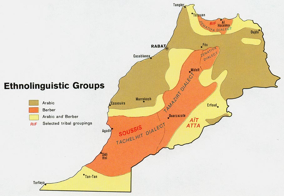
The Atlas series of mountain ranges in northwestern Africa extend 1200 miles southwest to northeast across the North African countries of Morocco, Algeria, and Tunisia. In northern Morocco, the Rif Mountains receive enough rainfall to support forests and a great diversity of wildlife; to the east, this range becomes the Tell Atlas. Further south, the broad belt of the Middle Atlas and then the High Atlas (peaking at Mount Toubkal, standing at 13,665 feet or 4165 meters) and then the Saharan Atlas ranges separate the Mediterranean basin from the Sahara Desert to the south. On the north-facing slopes of this great climate barrier, rich farmland exists.
The Atlas mountain ranges not only restrict the passage of water from the verdant Mediterranean edge to the Sahara, but also have played a role in restricting the movement of humans. In this difficult terrain, over the centuries of conquest by new groups such as the Arabs and the French, the indigenous culture of the various Imazighen peoples (or Berbers) has survived centuries. This map of Morocco, its mountains and its ethnic groups shows how the Berber population is concentrated in mountainous areas: http://www.lib.utexas.edu/maps/africa/morocco_ethno_1973.jpg (map credit to Perry Castaneda library).
The Lebanon Mountains, along with the Anti-Lebanon Mountains further to the east, parallel the Mediterranean coast from southern Lebanon into Syria. Between the two ranges lies the fertile Bekaa Valley. In ancient times, Lebanon was famous for the huge cedar trees that grew in the Lebanon Mountains and which still appear on its flag, although there are very few specimens remaining. Like the Atlas, the Lebanon Mountains have long been a refuge for minority groups wishing to escape both persecution and assimilation into the dominant culture. In this case, the mountains have provided refuge over the centuries for Christians, particularly the Maronites; the Druze; and communities of Shi’a Muslims.
Further Resources:
See a discussion of why so many earthquakes occur in Iran here.
There is also an excellent poster showing earthquake activity in Iran and photos from the Bam earthquake from the United States Geologic Society here.
For a map of the major landforms of the Middle East:
http://www.worldatlas.com/webimage/countrys/melnd.htm
Activity: You can take a short online quiz to see if you can correctly place the major Middle Eastern mountain ranges here.